We haven't seen a product like this before and since it's targeted to geocachers, thought we'd share it: a wireless geocaching beacon. At the very least, it could serve as an "intelligent" geocache, perhaps at its best, it could better allow those with low vision to have a better geocaching experience.
from the Garmin website:
chirp is a one-of-a-kind wireless beacon designed specifically for the outdoor adventures of geocaching. Affordable, durable and waterproof, chirp can communicate with, and be programmed by, any compatible wireless-enabled Garmin handheld (sold separately). chirp stores hints, multicache coordinates, counts visitors and confirms the cache is nearby. chirp is password protected and has a battery life of up to one year.
Get & Store Hints
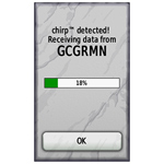 | 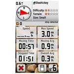 |
chirp detection screen (on an Oregon) | Trip computer screen showing chirp detection indication on dashboard (on an Oregon) |
chirp can be programmed by any compatible wireless-enabled Garmin handheld to store geocaching hints and other information. When other geocachers arrive near your cache, they’ll be alerted that the cache is nearby, and then they’ll be able to access the hints you’ve loaded into chirp. And when you return, chirp will tell you how many visitors have been to your cache.


.jpg)

.jpg)


